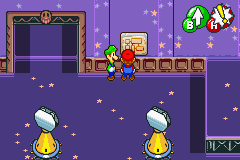
Region map
A Region Map is an object found in the Beanbean Kingdom in the game Mario & Luigi: Superstar Saga. Region maps are first seen in the Chucklehuck Woods, later appearing in Woohoo Hooniversity, Oho Ocean, Teehee Valley, Gwarhar Lagoon, and Joke's End. A region map is always found on a wall. When the Mario brothers consult the map, a basic diagram of the area they are currently in is shown. An animated sprite shows the area of the region the brothers are currently in, while the blue sprites on the map show Save Blocks and their locations in the region.
Gallery
File:MLSS-Chucklehuck Woods Map.png|Chucklehuck Woods File:MLSS-Gwarhar Lagoon Map.png|Gwarhar Lagoon File:MLSS-Jokes End Map.png|Joke's End File:MLSS-Oho Ocean Map.png|Oho Ocean File:MLSS-Teehee Valley Map.png|Teehee Valley File:MLSS-Woohoo Honiversity Map.png|Woohoo Hooniversity
